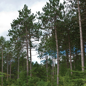
Researchers propose method to estimate forest biomass cover

November 1, 2012
BY Erin Krueger
Advertisement
Advertisement
Related Stories

Australia Department of Defence’s Pacific Support Vessel, ADV Reliant, has achieved a major milestone in strengthening the nations fuel resilience by refueling with renewable diesel for the first time.

PBF Energy Inc. on Oct. 29 announced the St. Bernard Renewables facility produced approximately 15,400 barrels per day of renewable diesel during the third quarter. Production is expected to expand slightly during the final quarter of the year.

CVR Energy Inc. on Oct. 29 announced plans to revert the renewable diesel unit at its refinery in Wynnewood, Oklahoma, back to hydrocarbon processing service during the next scheduled catalyst change in December.

Rep. Mike Thompson, D-Calif., on Oct. 28 introduced a bill that aims to reinstate many of the renewable energy tax credits eliminated by the One Big Beautiful Bill, including the reinstatement of the 45Z clean fuel production credit “special rate” for SAF.
Plug Power Inc. on Oct. 23 announced a strategic partnership with Edgewood Renewables to support the development and construction of its advanced renewable fuel facility in North Las Vegas, Nevada, that will produce SAF and renewable diesel.
Upcoming Events

@ Copyright 2025 - BBI International - All rights reserved.